Explore the Michinoku Coastal Trail in Japan: A Unique Hiking Experience
A stunning long-distance hiking route that stretches along the eastern coastline of Japan’s Tohoku region. The trail offers hikers an unforgettable adventure through nature, culture, and history.
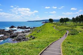
Hachinohe section of the Michinoku Coastal Trail, © Rekall
‘Michinoku’ – meaning ‘the end of the road’.
What is the Michinoku Coastal Trail?
The Michinoku Coastal Trail is a scenic hiking path that runs for about 1,000 kilometers (620 miles), from Fukushima Prefecture in the south to Aomori Prefecture in the north. Created to promote recovery after the 2011 Great East Japan Earthquake and Tsunami, the trail highlights the region’s natural beauty while showcasing local recovery efforts.
Trail Length and Duration
The entire Michinoku Coastal Trail spans roughly 1,000 kilometers, with most hikers completing the route in about 50 days. However, many choose to hike in sections, making it accessible for those with limited time.
Types of Accommodation on the Michinoku Trail
There are around 25 campsites along the trail, including one on the famous “Cat Island” (Tashirojima), which is accessible via a short boat ride from Ishinomaki City. Wild camping is not widely practiced in Japan, so it’s recommended to stay at designated campsites when camping.
Support Local Businesses
Whenever possible, consider staying at local minshuku or ryokan (traditional inns) to support the local communities along the trail.
- Ryokan: Traditional Japanese inns featuring tatami rooms and offering meals like dinner and breakfast. A great way to experience authentic Japanese hospitality.
- Minshuku: Family-run bed-and-breakfast accommodations with Japanese-style rooms and home-cooked meals, often at a more affordable price.
- Pensions: Similar to minshuku but with Western-style rooms, commonly found in resort towns and rural areas.
- Hostels: Budget-friendly options with shared facilities, ideal for solo travelers or backpackers.
Booking Tips
- Plan Ahead: Accommodations can be sparse in rural areas, so it’s important to reserve your stay a few days in advance. This is especially true for smaller, family-run inns that require preparation time for meals and rooms.
- Weekend Caution: Hotels often book up quickly on weekends and holidays. To avoid disappointment, secure your reservations as early as possible.
- Language Barriers: Many small inns and ryokan are listed only on Japanese-language booking platforms, which can make it difficult to book without Japanese language skills.
How to Overcome Language Challenges
- Ask for Help: If you have a Japanese-speaking friend or colleague, ask them to assist with booking.
- Use Booking Services: Companies like Michinoku Hikers specialize in helping English-speaking hikers book accommodations and navigate the trail.
- Real-Time Support: Services like OYRAA allow you to call accommodations with an interpreter on the line, making communication and booking much easier.
How to get to the Michinoku Trail
Northern Trailhead: Kabushima Shrine, Hachinohe City (Aomori Prefecture)
The northern starting point is located near Same Station (鮫駅), just a short walk from Kabushima Shrine. Fun fact: Same (pronounced “sam-eh”) means shark in Japanese, and there’s a striking shark statue outside the station—perfect for a selfie before you start your journey!
How to Get There:
- By Shinkansen (Bullet Train):
Take the Shinkansen to Hachinohe Station (八戸駅). - From Tokyo: The journey takes approximately 3 hours and costs around ¥17,000 / £80.
- From Hachinohe Station to Same Station: Transfer to the Hachinohe Line, which takes 21 minutes and costs ¥240 / £1.50.
Southern Trailhead: Matsukawaura Kankyo Koen, Soma City (Fukushima Prefecture)
The southern trailhead is located at Matsukawaura Kankyo Koen, a park in Soma City. From Soma Station, you can either take a short bus ride (15 minutes, ¥310) or it is a 3.7 km walk!
How to Get There:
- By Shinkansen (Bullet Train):
Take the Shinkansen to Sendai Station (仙台駅).- From Tokyo Station to Sendai Station: The journey takes 1.5–2 hours and costs approximately ¥12,000 / £62.
- From Sendai to Soma Station:
- Take the Joban Line (58 minutes, ¥990 / £5), or
- Use the HITACHI and TOKIWA Limited Express (37 minutes, ¥2,000 / £10).
Northbound or Southbound? Get more detailed information and top tips about your direction of travel and pre-book your boat tickets
Offline: While much of the trail has mobile coverage, there are remote sections where your phone may lose signal. Be prepared by carrying physical maps or ensuring your navigation tools are accessible offline.
Water: Tap water in Japan is drinkable.
Bears: In some areas, particularly in Aomori and northern Iwate prefectures, you’ll encounter signs warning about bears. These bears are generally shy and tend to avoid humans, but it’s always wise to stay alert and follow safety guidelines.


